MUMBAI – The festive season witnesses a slew of new car launches including special edition offerings and other variants. With so much promotional activity undertaken by brands, it is important to stand out of the clutter and create an impact that will leave a memorable impression in the marketplace. True to its promise, ŠKODA Auto India has now launched its latest model, the new Rapid Onyx, which boasts unique features and a special price that makes it the best in the segment.
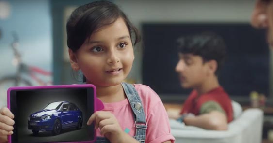
The auto major has launched an integrated ad campaign that has been conceptualized and executed by Publicis India. As part of the ad campaign, the agency has launched a TVC that keeps the family at the heart of decision-making when it comes to car purchase. And who better to do the selling than kids, who know the best way to convince their parents into buying a car of their choice.
In the TVC, we see a daughter trying hard to convince her strict dad to buy the latest Rapid Onyx, but in turn receives an unexpected surprise reaction from him. The film captures the many features of the new car including the reasonable price tag it carries, and why it is a family winner all the way.
Commenting on the film, Tarun Jha – Head of Marketing and Product, ŠKODA AUTO India Pvt. Ltd. said: “ŠKODA is a human brand and in all our communication, we try to bring a human story which our consumers can relate to better. Similarly, our products and features are designed keeping consumers in mind. With the Rapid Onyx, we wanted to delight the customers with not only features but also the price point. We have managed to do all that keeping the family’s core interest in mind.”
Adding his views, Paritosh Srivastava, COO, Publicis Ambience said: “The biggest challenge was to do a pure product film in the tonality of brand ŠKODA. Weaving a family story around the product features does the job nicely for us. The added benefit obviously is the pester power we appeal to that is playing increasingly an important role in big purchases in any home. We’re confident that in the clutter of festivals we will stand out with this communication.”
The campaign has been launched on air and will also explore popular offline and online mediums like print, outdoor, digital etc.
It is commendable to note here that in ŠKODA’s almost two decade long presence in India, their partnership with Publicis India has been the longest among all agency partners.
Team Credits:
Client: ŠKODA Auto
Agency: Publicis Ambience
Brand: ŠKODA Auto
MD& CCO: Bobby Pawar
MD: Srija Chatterjee
COO: Paritosh Srivastava
Head of Creative: Ramakrishnan Hariharan
Creative Team: Nishant Jethi, Durgesh Singh, Avinash Jakhalekar,
Account Management: Nikhil Kumar, Punit Bhatt, Fouzia Bukhari
Account Planning: Abhinit Agarwal
Production House: Bow Chicka Wow Wow
Films: Jignesh Maru